Think the tropics are just lines on a map? Think again. Here is how solar radiation, trade winds, and melting butter define the zone
What actually constitutes ‘the tropics’? Navigationally, it’s straightforward: the tropics lie between the Tropic of Cancer at 23° 26’N and the Tropic of Capricorn at 23° 26’S, which mark the northern and southern limits of the sun’s travel. However, understanding the tropics requires a deeper dive into the atmospheric and oceanic dynamics that distinguish this vibrant region of our planet.
Solar Radiation: The Heart of the Tropics
A better way to conceptualize the tropics is through the lens of solar energy. Each point on Earth receives a different amount of energy from the sun based on its latitude. Essentially, equatorial regions enjoy more direct sunlight than polar areas, resulting in an energy imbalance. The tropics, therefore, are defined as regions that receive more solar radiation than they reradiate. This intriguing imbalance creates an ecosystem constantly transporting heat from the tropics towards the poles.
This leads to a practical meteorological definition of the tropics, encompassing areas between the subtropical ocean high-pressure systems and the equator, roughly within 30°N to 30°S. It’s a dynamic zone where warmth and moisture intermingle, creating a unique climatic experience.
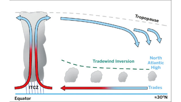
The North Atlantic Hadley Cell, from sea level to the tropopause, the transition zone between the troposphere and the stratosphere.
The Hadley Cell: A Heat Transport Mechanism
One of the primary systems responsible for transporting heat away from the tropics is the Hadley Cell—an atmospheric circulation that extends to each side of the equator. More specifically, in the North Atlantic, excess heat from the tropics is carried upward by convection in the Intertropical Convergence Zone (ITCZ), where warm air rises and moves poleward in the upper atmosphere. By the time this air reaches approximately 30°N latitude, it cools, becomes denser, and descends, contributing to the formation of high-pressure systems like the North Atlantic High.
This descending air creates a temperature inversion, suppressing surface heating and inhibiting convection, effectively sealing off the trade wind clouds. Interestingly, the air within these trades is significantly warmer than it is in mid-latitudes, allowing it to hold much more moisture. Thus, when it rains in tropical regions, it tends to be far more intense than in moderate climates, making it wise to keep rain gear handy.
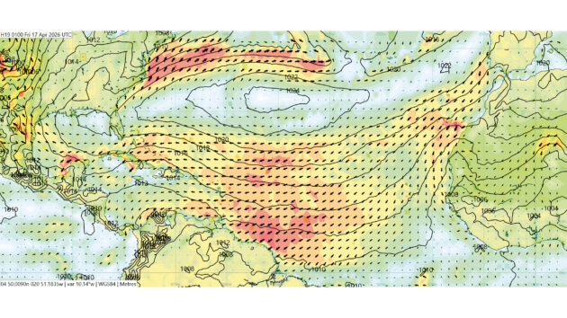
10m winds (knots) and mean sea level pressure (2mb isobars), for 17 February 2026.
Trade Winds: Navigating the Tropics
The trade winds serve as a crucial aspect of tropical weather patterns, driven primarily by pressure differences between the mid-ocean high-pressure systems and the ITCZ. The Coriolis effect influences these winds, causing them to bend to the right in the Northern Hemisphere, which can significantly impact weather predictions in the tropics.
The winds generally originate south of the Canary Islands at around 25°N. The maritime wisdom among sailors—“go south until the butter melts, then turn right”—hints at the strength of the trade winds in that region. Here, the ITCZ remains fairly stable at consistent pressure, making the mid-ocean high the driving force behind the strength of these winds.
An important point to note is that the tropics generally feature a single air mass, which diminishes the occurrence of weather fronts. However, during winter, deep low-pressure systems can migrate poleward, dragging cold fronts into the tropics and disrupting traditional trade wind patterns.
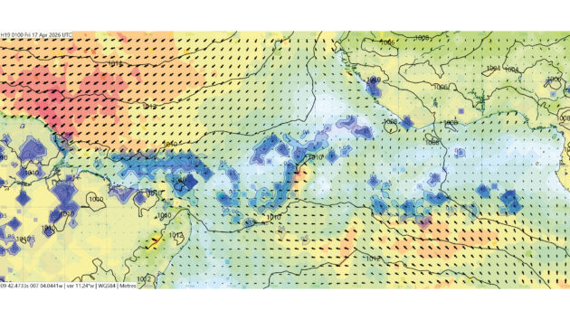
The ITCZ with mean sea level pressure (2mb isobars), wind (knots), and rain (blue shading) for 17 February 2026.
The Doldrums: More Than Just Windlessness
The ITCZ, often dubbed the doldrums, has a reputation for being a windless expanse, but this is an oversimplification. In reality, traversing the ITCZ can be a complex challenge, as winds shift direction and strength unpredictably, which can confuse those unfamiliar with sailing in these regions. This area marks the convergence of the northeast and southeast trades where the two Hadley Cells meet.
In the North Atlantic, the position of the ITCZ shifts from just north of the equator in December to around 10°N in July and August. It is noticeably wider near the West African coast, where southeast trades curve due to the Coriolis effect, transitioning from south or southwest winds as they approach the ITCZ.
Navigators can often anticipate their approach to the ITCZ upon spotting wispy cirrus clouds moving counter to surface winds—an indicator that they are nearing this dynamic zone. While often imagined as a uniform boundary, the ITCZ can range in width from 50 to 300 miles, moving regularly in response to seasonal changes. Crossing it can be tricky; the wise sailor monitors for shifts, as the lack of a prevailing wind creates turbulent conditions where one minute’s leeward side might become the next’s windward.

The North Atlantic has a low at 36°N 029°W, trailing a front down to the south-west, effectively splitting the high.
Navigating the Tropics: A Joyful Endeavor
Despite the complexities of sailing through tropical regions, the experience is often rewarding, characterized by warm climates, steady weather, and beautiful destinations. The unique heat and humidity can result in swift weather changes, making consistent weather checks essential for sailors. Ultimately, knowledge of tropical systems—solar energy dynamics, the Hadley Cell, trade winds, and the ITCZ—opens up opportunities for safer and more enjoyable voyages in these vibrant waters.